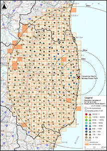
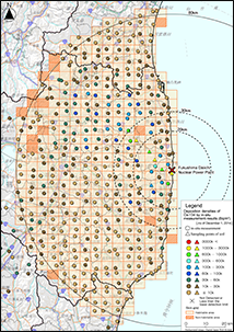
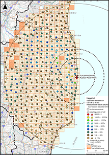
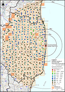
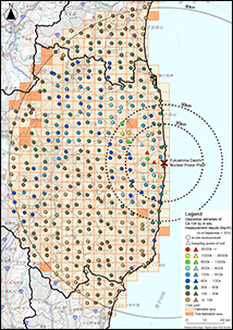
Results of Deposition Density Measurement of Gamma-emitting Nuclides on Soil within the 80 km Radius from Fukushima Dai-ichi NPP. ( From August 2016 to October 2016 )
- This data was created based on results of soil deposition densities of gamma-emitting nuclides measured from August 24, 2016 to October 6, 2016 in the FY2014 Distribution Survey by NRA.
- The definition of the "soil deposition" is the radioactivity per unit area (Bq/m2), that is, the radioactivity integrated along the depth direction.
- The measurements to obtain this data were conducted to ascertain the influence of typhoon to the change of air dose rate and also to ascertain the changing trend of air dose rate from the past measured results taken within the 80 km radius from the Fukushima Dai-ichi NPP.
- The area within an 80 km radius from the Fukushima Dai-ichi NPP was divided into 5 km × 5 km grids. Excluding the non-habitable areas and the areas where were inaccessible due to blocked roads, one measurement point in each grid was selected (total 382 measurement points).
- Regarding radioactive cesium measurement, we carried out in-situ measurements using portable germanium semiconductor detectors*1. At survey points which had shown very high air dose rates or where it was otherwise found that proper in-situ measurement would be difficult (6 measurement points), we carried out the measurements in the manner used in the First Distribution Survey: collecting soil samples to a depth of 5 cm from the surface at five different spots surrounding each survey point, stirring the collected soil samples well, and conducting nuclide analysis using fixed germanium semiconductor detectors.
- ND: The peak of relevant nuclide was not clearly detected in the in-situ measurement, or the deposition density calculated was below the measurement lower limit.
- ND in the column "Deposition", "-" in the column "Error", and Detection limit value as reference in the column "Detection Limit": The peak of relevant nuclide was not clearly detected or the calculated deposition was equal to or below 0.0. Reference value in the column "Deposition" smaller than the detection limit in the column "Detection Limit": The peak of the relevant nuclide was detected even though the calculated deposition was below detection limit.
- Arithmetic average including values below the detection limit when at least one measured value was equal to or above the detection limit in soil samples or "-" when measured values of all samples were below the detection limit.
- Considering the physical half-lives of radionuclides (Cs-134: 2.0648 years; Cs-137: 30.1671years; Ag-110m: 249.95 days), the obtained values were corrected for their decay as of October 1, 2015.
- *1: These measurements were conducted by analyzing the average concentration of radioactive substances accumulated in soil by installing portable germanium semiconductor detectors in the environment (at flat places without any buildings, etc. nearby), carrying out measurements of the overall soil surface, and measuring the gamma rays emitted by radiation sources distributed in the soil. This survey was conducted based on MEXT's Radiation Measurement Method Series, “In-situ Measurement Using Germanium Semiconductor Detectors” and by referring to ICRU report 53 (1994) for the basic data of analysis. In addition, the relaxation mass depth (the depth where radioactivity concentration of radioactive cesium reaches 1/e*2 of the concentration at the ground surface) of 2.62±1.99 g/cm2 (as of December 2013) was used based on the results of the soil depth distribution survey in this project and past results of the MEXT's survey for radioactive cesium depth distribution.
- *2: The mathematical constant "e" is used as the base of the natural logarithm, and is about 2.72.
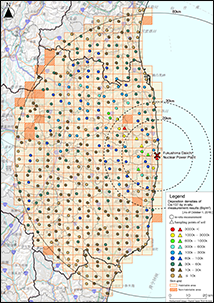
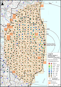
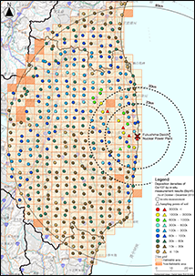
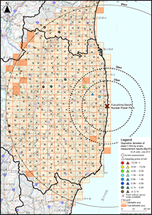
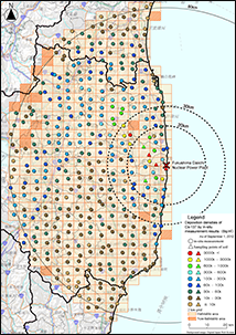
Results of Deposition Density Measurement of Gamma-emitting Nuclides on Soil within the 80 km Radius from Fukushima Dai-ichi NPP. ( From August 2015 to October 2015 )
- This data was created based on results of soil deposition densities of gamma-emitting nuclides measured from August 24, 2015 to October 7, 2015 in the FY2014 Distribution Survey by NRA.
- The definition of the "soil deposition" is the radioactivity per unit area (Bq/m2), that is, the radioactivity integrated along the depth direction.
- The measurements to obtain this data were conducted to ascertain the influence of typhoon to the change of air dose rate and also to ascertain the changing trend of air dose rate from the past measured results taken within the 80 km radius from the Fukushima Dai-ichi NPP.
- The area within an 80 km radius from the Fukushima Dai-ichi NPP was divided into 5 km × 5 km grids. Excluding the non-habitable areas and the areas where were inaccessible due to blocked roads, one measurement point in each grid was selected (total 382 measurement points).
- Regarding radioactive cesium measurement, we carried out in-situ measurements using portable germanium semiconductor detectors*1. At survey points which had shown very high air dose rates or where it was otherwise found that proper in-situ measurement would be difficult (6 measurement points), we carried out the measurements in the manner used in the First Distribution Survey: collecting soil samples to a depth of 5 cm from the surface at five different spots surrounding each survey point, stirring the collected soil samples well, and conducting nuclide analysis using fixed germanium semiconductor detectors.
- ND: The peak of relevant nuclide was not clearly detected in the in-situ measurement, or the deposition density calculated was below the measurement lower limit.
- ND in the column "Deposition", "-" in the column "Error", and Detection limit value as reference in the column "Detection Limit": The peak of relevant nuclide was not clearly detected or the calculated deposition was equal to or below 0.0. Reference value in the column "Deposition" smaller than the detection limit in the column "Detection Limit": The peak of the relevant nuclide was detected even though the calculated deposition was below detection limit.
- Arithmetic average including values below the detection limit when at least one measured value was equal to or above the detection limit in soil samples or "-" when measured values of all samples were below the detection limit.
- Considering the physical half-lives of radionuclides (Cs-134: 2.0648 years; Cs-137: 30.1671years; Ag-110m: 249.95 days), the obtained values were corrected for their decay as of October 1, 2015.
- *1: These measurements were conducted by analyzing the average concentration of radioactive substances accumulated in soil by installing portable germanium semiconductor detectors in the environment (at flat places without any buildings, etc. nearby), carrying out measurements of the overall soil surface, and measuring the gamma rays emitted by radiation sources distributed in the soil. This survey was conducted based on MEXT's Radiation Measurement Method Series, “In-situ Measurement Using Germanium Semiconductor Detectors” and by referring to ICRU report 53 (1994) for the basic data of analysis. In addition, the relaxation mass depth (the depth where radioactivity concentration of radioactive cesium reaches 1/e*2 of the concentration at the ground surface) of 2.62±1.99 g/cm2 (as of December 2013) was used based on the results of the soil depth distribution survey in this project and past results of the MEXT's survey for radioactive cesium depth distribution.
- *2: The mathematical constant "e" is used as the base of the natural logarithm, and is about 2.72.
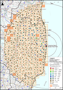
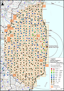
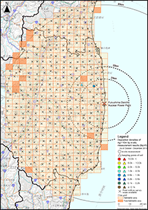
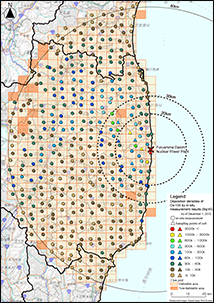
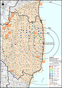
Results of Deposition Density Measurement of Gamma-emitting Nuclides on Soil within the 80 km Radius from Fukushima Dai-ichi NPP. ( From October 2014 to December 2014 )
- This data was created based on results of soil deposition densities of gamma-emitting nuclides measured from October 27, 2014 to December 5, 2014 in the FY2014 Distribution Survey by NRA.
- The definition of the "soil deposition" is the radioactivity per unit area (Bq/m2), that is, the radioactivity integrated along the depth direction.
- The measurements to obtain this data were conducted to ascertain the influence of typhoon to the change of air dose rate and also to ascertain the changing trend of air dose rate from the past measured results taken within the 80 km radius from the Fukushima Dai-ichi NPP.
- The measurement site of radioactive cesium was divided into 5 km × 5 km meshes in the area within 80 km from Fukushima Daiichi Nuclear Power Station and the areas where residents did not exist even before the Fukushima Daiichi nuclear accident In the mesh, except for the public land, we selected one place suitable for measurement etc., which is a flat open land with little artificial disturbance. In addition, out of the 80 kilometers surveyed from December 2011 to April 2012, a place where the air dose rate at the time of March 2012 as evaluated as 0.3 μSv / h or more is selected Measurement was carried out. Measurement was carried out at 473 places except where the road to the measurement site was difficult to measure due to road closure etc.
- Regarding radioactive cesium measurement, we carried out in-situ measurements using portable germanium semiconductor detectors*1. At survey points which had shown very high air dose rates or where it was otherwise found that proper in-situ measurement would be difficult (6 measurement points), we carried out the measurements in the manner used in the First Distribution Survey: collecting soil samples to a depth of 5 cm from the surface at five different spots surrounding each survey point, stirring the collected soil samples well, and conducting nuclide analysis using fixed germanium semiconductor detectors.
- ND: The peak of relevant nuclide was not clearly detected in the in-situ measurement, or the deposition density calculated was below the measurement lower limit.
- ND in the column "Deposition", "-" in the column "Error", and Detection limit value as reference in the column "Detection Limit": The peak of relevant nuclide was not clearly detected or the calculated deposition was equal to or below 0.0. Reference value in the column "Deposition" smaller than the detection limit in the column "Detection Limit": The peak of the relevant nuclide was detected even though the calculated deposition was below detection limit.
- Arithmetic average including values below the detection limit when at least one measured value was equal to or above the detection limit in soil samples or "-" when measured values of all samples were below the detection limit.
- Considering the physical half-lives of radionuclides (Cs-134: 2.0648 years; Cs-137: 30.1671years; Ag-110m: 249.95 days), the obtained values were corrected for their decay as of December 1, 2014.
- *1: These measurements were conducted by analyzing the average concentration of radioactive substances accumulated in soil by installing portable germanium semiconductor detectors in the environment (at flat places without any buildings, etc. nearby), carrying out measurements of the overall soil surface, and measuring the gamma rays emitted by radiation sources distributed in the soil. This survey was conducted based on MEXT's Radiation Measurement Method Series, “In-situ Measurement Using Germanium Semiconductor Detectors” and by referring to ICRU report 53 (1994) for the basic data of analysis. In addition, the relaxation mass depth (the depth where radioactivity concentration of radioactive cesium reaches 1/e*2 of the concentration at the ground surface) of 2.62±1.99 g/cm2 (as of December 2013) was used based on the results of the soil depth distribution survey in this project and past results of the MEXT's survey for radioactive cesium depth distribution.
- *2: The mathematical constant "e" is used as the base of the natural logarithm, and is about 2.72.
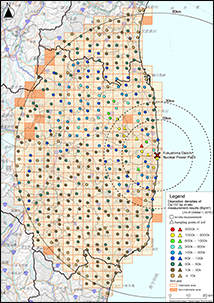
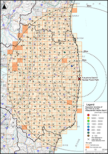
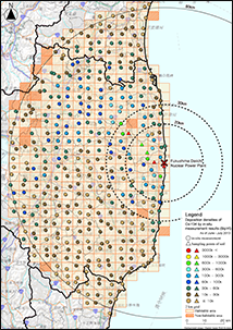
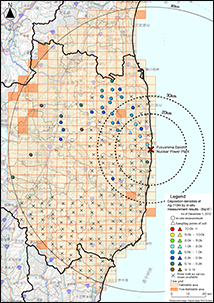
Results of Deposition Density Measurement of Gamma-emitting Nuclides on Soil within the 80 km Radius from Fukushima Dai-ichi NPP. ( From June 2014 to July 2014 )
- This data was created based on results of soil deposition densities of gamma-emitting nuclides measured from June 23, 2014 to July 30, 2014 in the FY2014 Distribution Survey by NRA.
- The definition of the "soil deposition" is the radioactivity per unit area (Bq/m2), that is, the radioactivity integrated along the depth direction.
- The measurements to obtain this data were conducted to ascertain the influence of typhoon to the change of air dose rate and also to ascertain the changing trend of air dose rate from the past measured results taken within the 80 km radius from the Fukushima Dai-ichi NPP.
- The measurement site of radioactive cesium was divided into 5 km × 5 km meshes in the area within 80 km from Fukushima Daiichi Nuclear Power Station and the areas where residents did not exist even before the Fukushima Daiichi nuclear accident In the mesh, except for the public land, we selected one place suitable for measurement etc., which is a flat open land with little artificial disturbance. In addition, out of the 80 kilometers surveyed from December 2011 to April 2012, a place where the air dose rate at the time of March 2012 as evaluated as 0.3 μSv / h or more is selected Measurement was carried out. Measurement was carried out at 473 places except where the road to the measurement site was difficult to measure due to road closure etc.
- Regarding radioactive cesium measurement, we carried out in-situ measurements using portable germanium semiconductor detectors*1. At survey points which had shown very high air dose rates or where it was otherwise found that proper in-situ measurement would be difficult (6 measurement points), we carried out the measurements in the manner used in the First Distribution Survey: collecting soil samples to a depth of 5 cm from the surface at five different spots surrounding each survey point, stirring the collected soil samples well, and conducting nuclide analysis using fixed germanium semiconductor detectors.
- ND: The peak of relevant nuclide was not clearly detected in the in-situ measurement, or the deposition density calculated was below the measurement lower limit.
- ND in the column "Deposition", "-" in the column "Error", and Detection limit value as reference in the column "Detection Limit": The peak of relevant nuclide was not clearly detected or the calculated deposition was equal to or below 0.0. Reference value in the column "Deposition" smaller than the detection limit in the column "Detection Limit": The peak of the relevant nuclide was detected even though the calculated deposition was below detection limit.
- Arithmetic average including values below the detection limit when at least one measured value was equal to or above the detection limit in soil samples or "-" when measured values of all samples were below the detection limit.
- Considering the physical half-lives of radionuclides (Cs-134: 2.0648 years; Cs-137: 30.1671years; Ag-110m: 249.95 days), the obtained values were corrected for their decay as of July 1, 2014.
- *1: These measurements were conducted by analyzing the average concentration of radioactive substances accumulated in soil by installing portable germanium semiconductor detectors in the environment (at flat places without any buildings, etc. nearby), carrying out measurements of the overall soil surface, and measuring the gamma rays emitted by radiation sources distributed in the soil. This survey was conducted based on MEXT's Radiation Measurement Method Series, “In-situ Measurement Using Germanium Semiconductor Detectors” and by referring to ICRU report 53 (1994) for the basic data of analysis. In addition, the relaxation mass depth (the depth where radioactivity concentration of radioactive cesium reaches 1/e*2 of the concentration at the ground surface) of 2.62±1.99 g/cm2 (as of December 2013) was used based on the results of the soil depth distribution survey in this project and past results of the MEXT's survey for radioactive cesium depth distribution.
- *2: The mathematical constant "e" is used as the base of the natural logarithm, and is about 2.72.
Results of Deposition Density Measurement of Gamma-emitting Nuclides on Soil within the 80 km Radius from Fukushima Dai-ichi NPP. ( From October 2013 to December 2013 )
- This data was created based on results of soil deposition densities of gamma-emitting nuclides measured from October 28, 2013 to December 6, 2013 in the FY2013 Distribution Survey by NRA.
- The definition of the "soil deposition" is the radioactivity per unit area (Bq/m2), that is, the radioactivity integrated along the depth direction.
- The measurements to obtain this data were conducted to ascertain the influence of typhoon to the change of air dose rate and also to ascertain the changing trend of air dose rate from the past measured results taken within the 80 km radius from the Fukushima Dai-ichi NPP.
- The area within an 80 km radius from the Fukushima Dai-ichi NPP was divided into 5 km × 5 km grids. Excluding the non-habitable areas and the areas where were inaccessible due to blocked roads, one measurement point in each grid was selected (total 381 measurement points).
- Regarding radioactive cesium measurement, we carried out in-situ measurements using portable germanium semiconductor detectors*1. At survey points which had shown very high air dose rates or where it was otherwise found that proper in-situ measurement would be difficult (6 measurement points), we carried out the measurements in the manner used in the First Distribution Survey: collecting soil samples to a depth of 5 cm from the surface at five different spots surrounding each survey point, stirring the collected soil samples well, and conducting nuclide analysis using fixed germanium semiconductor detectors.
- ND: The peak of relevant nuclide was not clearly detected in the in-situ measurement, or the deposition density calculated was below the measurement lower limit.
- ND in the column "Deposition", "-" in the column "Error", and Detection limit value as reference in the column "Detection Limit": The peak of relevant nuclide was not clearly detected or the calculated deposition was equal to or below 0.0. Reference value in the column "Deposition" smaller than the detection limit in the column "Detection Limit": The peak of the relevant nuclide was detected even though the calculated deposition was below detection limit.
- Arithmetic average including values below the detection limit when at least one measured value was equal to or above the detection limit in soil samples or "-" when measured values of all samples were below the detection limit.
- Considering the physical half-lives of radionuclides (Cs-134: 2.0648 years; Cs-137: 30.1671years; Ag-110m: 249.95 days), the obtained values were corrected for their decay as of December 1, 2013.
- *1: These measurements were conducted by analyzing the average concentration of radioactive substances accumulated in soil by installing portable germanium semiconductor detectors in the environment (at flat places without any buildings, etc. nearby), carrying out measurements of the overall soil surface, and measuring the gamma rays emitted by radiation sources distributed in the soil. This survey was conducted based on MEXT's Radiation Measurement Method Series, “In-situ Measurement Using Germanium Semiconductor Detectors” and by referring to ICRU report 53 (1994) for the basic data of analysis. In addition, the relaxation mass depth (the depth where radioactivity concentration of radioactive cesium reaches 1/e*2 of the concentration at the ground surface) of 2.62±1.99 g/cm2 (as of December 2013) was used based on the results of the soil depth distribution survey in this project and past results of the MEXT's survey for radioactive cesium depth distribution.
- *2: The mathematical constant "e" is used as the base of the natural logarithm, and is about 2.72.
Results of Deposition Density Measurement of Gamma-emitting Nuclides on Soil within the 80 km Radius from Fukushima Dai-ichi NPP. ( From June 2013 to July 2013 )
- This data was created based on results of soil deposition densities of gamma-emitting nuclides measured from June 3, 2013 to July 10, 2013 in the FY2013 Distribution Survey by NRA.
- The definition of the "soil deposition" is the radioactivity per unit area (Bq/m2), that is, the radioactivity integrated along the depth direction.
- The measurements to obtain this data were conducted to ascertain the changing trend of air dose rate from the past measured results taken within the 80 km radius from the Fukushima Dai-ichi NPP.
- The area within an 80 km radius from the Fukushima Dai-ichi NPP was divided into 5 km × 5 km grids. Excluding the non-habitable areas and the areas where were inaccessible due to blocked roads, one measurement point in each grid was selected (total 381 measurement points).
- Regarding radioactive cesium measurement, we carried out in-situ measurements using portable germanium semiconductor detectors*1. At survey points which had shown very high air dose rates or where it was otherwise found that proper in-situ measurement would be difficult (7 measurement points), we carried out the measurements in the manner used in the First Distribution Survey: collecting soil samples to a depth of 5 cm from the surface at five different spots surrounding each survey point, stirring the collected soil samples well, and conducting nuclide analysis using fixed germanium semiconductor detectors.
- ND: The peak of relevant nuclide was not clearly detected in the in-situ measurement, or the deposition density calculated was below the measurement lower limit.
- ND in the column "Deposition", "-" in the column "Error", and Detection limit value as reference in the column "Detection Limit": The peak of relevant nuclide was not clearly detected or the calculated deposition was equal to or below 0.0. Reference value in the column "Deposition" smaller than the detection limit in the column "Detection Limit": The peak of the relevant nuclide was detected even though the calculated deposition was below detection limit.
- Arithmetic average including values below the detection limit when at least one measured value was equal to or above the detection limit in soil samples or "-" when measured values of all samples were below the detection limit.
- Considering the physical half-lives of radionuclides (Cs-134: 2.0648 years; Cs-137: 30.1671years; Ag-110m: 249.95 days), the obtained values were corrected for their decay as of July 1, 2013.
- *1:These measurements were conducted by analyzing the average concentration of radioactive substances accumulated in soil by installing portable germanium semiconductor detectors in the environment (at flat places without any buildings, etc. nearby), carrying out measurements of the overall soil surface, and measuring the gamma rays emitted by radiation sources distributed in the soil. This survey was conducted based on MEXT's Radiation Measurement Method Series, “In-situ Measurement Using Germanium Semiconductor Detectors” and by referring to ICRU report 53 (1994) for the basic data of analysis. In addition, the relaxation mass depth (the depth where radioactivity concentration of radioactive cesium reaches 1/e*2 of the concentration at the ground surface) of 2.06 g/cm2 (as of July 2013) was used based on the results of the soil depth distribution survey in this project and past results of the MEXT's survey for radioactive cesium depth distribution.
- *2: The mathematical constant "e" is used as the base of the natural logarithm, and is about 2.72.
Results of Deposition Density Measurement of Gamma-emitting Nuclides on Soil within the 80 km Radius from Fukushima Dai-ichi NPP. ( Decay correction: December 1, 2012 )
- This data was created based on results of soil deposition densities of gamma-emitting nuclides measured from November 5, 2012 to December 12, 2012 in the Third Distribution Survey by MEXT.
- The definition of the "soil deposition" is the radioactivity per unit area (Bq/m2), that is, the radioactivity integrated along the depth direction.
- The measurements to obtain this data were conducted to ascertain the influence of typhoon to the change of air dose rate and also to ascertain the changing trend of air dose rate from the past measured results taken within the 80 km radius from the Fukushima Dai-ichi NPP.
- The area within an 80 km radius from the Fukushima Dai-ichi NPP was divided into 5 km × 5 km grids. Excluding the non-habitable areas and the areas where were inaccessible due to blocked roads, one measurement point in each grid was selected (total 380 measurement points).
- Regarding radioactive cesium measurement, we carried out in-situ measurements using portable germanium semiconductor detectors*1. At survey points which had shown very high air dose rates or where it was otherwise found that proper in-situ measurement would be difficult (7 measurement points), we carried out the measurements in the manner used in the First Distribution Survey: collecting soil samples to a depth of 5 cm from the surface at five different spots surrounding each survey point, stirring the collected soil samples well, and conducting nuclide analysis using fixed germanium semiconductor detectors.
- ND: The peak of relevant nuclide was not clearly detected in the in-situ measurement, or the deposition density calculated was below the measurement lower limit.
- ND in the column "Deposition", "-" in the column "Error", and Detection limit value as reference in the column "Detection Limit": The peak of relevant nuclide was not clearly detected or the calculated deposition was equal to or below 0.0. Reference value in the column "Deposition" smaller than the detection limit in the column "Detection Limit": The peak of the relevant nuclide was detected even though the calculated deposition was below detection limit.
- Arithmetic average including values below the detection limit when at least one measured value was equal to or above the detection limit in soil samples or "-" when measured values of all samples were below the detection limit.
- Considering the physical half-lives of radionuclides (Cs-134: 2.0648 years; Cs-137: 30.1671years; Ag-110m: 249.95 days), the obtained values were corrected for their decay as of December 1, 2012.
- *1: These measurements were conducted by analyzing the average concentration of radioactive materials accumulated in soil by installing portable germanium semiconductor detectors in the environment (at flat places without any buildings, etc. nearby), carrying out measurements of the overall soil surface, and measuring the gamma rays emitted by radiation sources distributed in the soil. This survey was conducted based on MEXT's Radiation Measurement Method Series, “In-situ Measurement Using Germanium Semiconductor Detectors” and by referring to ICRU report 53 (1994) for the basic data of analysis. In addition, 1.2 g/cm2 was assumed as a parameter to show the vertical distribution of radionuclides in soil based on the results of radioactive cesium depth distribution in the Second Distribution Survey.
Results of Deposition Density Measurement of Gamma-emitting Nuclides on Soil within the 80 km Radius from Fukushima Dai-ichi NPP. ( Decay correction: September 1, 2012 )
- This data was created based on results of soil deposition densities of gamma-emitting nuclides measured from August 13, 2012 to September 29, 2012 in the Third Distribution Survey by MEXT.
- The definition of the "soil deposition" is the radioactivity per unit area (Bq/m2), that is, the radioactivity integrated along the depth direction.
- The measurements to obtain this data were conducted to ascertain the influence of typhoon to the change of air dose rate and also to ascertain the changing trend of air dose rate from the past measured results taken within the 80 km radius from the Fukushima Dai-ichi NPP.
- The area within an 80 km radius from the Fukushima Dai-ichi NPP was divided into 5 km × 5 km grids. Excluding the non-habitable areas and the areas that were inaccessible due to blocked roads, one measurement point in each grid was selected (total 381 measurement points).
- Regarding radioactive cesium measurement, we carried out in-situ measurements using portable germanium semiconductor detectors*1. At survey points which had shown very high air dose rates or where it was otherwise found that proper in-situ measurement would be difficult (6 measurement points), we carried out the measurements in the manner used in the First Distribution Survey: collecting soil samples to a depth of 5 cm from the surface at five different spots surrounding each survey point, stirring the collected soil samples well, and conducting nuclide analysis using fixed germanium semiconductor detectors.
- ND: The peak of relevant nuclide was not clearly detected in the in-situ measurement, or the deposition density calculated was below the measurement lower limit.
- ND in the column "Deposition", "-" in the column "Error", and Detection limit value as reference in the column "Detection Limit": The peak of relevant nuclide was not clearly detected or the calculated deposition was equal to or below 0.0. Reference value in the column "Deposition" smaller than the detection limit in the column "Detection Limit": The peak of the relevant nuclide was detected even though the calculated deposition was below detection limit.
- Arithmetic average including values below the detection limit when at least one measured value was equal to or above the detection limit in soil samples or "-" when measured values of all samples were below the detection limit.
- Considering the physical half-lives of radionuclides (Cs-134: 2.0648 years; Cs-137: 30.1671years; Ag-110m: 249.95 days), the obtained values were corrected for their decay as of September 1, 2012.
- *1: These measurements were conducted by analyzing the average concentration of radioactive materials accumulated in soil by installing portable germanium semiconductor detectors in the environment (at flat places without any buildings, etc. nearby), carrying out measurements of the overall soil surface, and measuring the gamma rays emitted by radiation sources distributed in the soil. This survey was conducted based on MEXT's Radiation Measurement Method Series, "In-situ Measurement Using Germanium Semiconductor Detectors" and by referring to ICRU report 53 (1994) for the basic data of analysis. In addition, 1.2 g/cm2 was assumed as a parameter to show the vertical distribution of radionuclides in soil based on the results of radioactive cesium depth distribution in the Second Distribution Survey.
Soil Deposition of Gamma-emitting Nuclides in Eastern Japan ( Decay correction: March 1, 2012 )
- This data was created based on results of soil deposition densities of gamma-emitting nuclides measured from December 13, 2011 to May 29, 2012 in "the Second Survey on the Distribution Condition of Radioactive Substances by MEXT due to the Accident at TEPCO’s Fukushima Dai-ichi NPP".
- The definition of "soil deposition" is the radioactivity per unit area, that is, the radioactivity integrated along the depth direction.
- Soil deposition measurement of gamma-emitting nuclides were conducted in the areas where the air dose rates were equal to or above 0.2 µSv/h (equivalent to approximately 1 mSv of the annual external dose)*1. The distribution of the measurement points is one point per every 5 km x 5 km grid where the air dose rate was equal to or above 0.2 and one point per every 10 km x 10 km grid where the air dose rate was below 0.2.
- Through the First Distribution Survey, it was confirmed that deposition densities of radioactive nuclides on the ground surface vary even within small areas (3 meters square). Therefore, in the Second Distribution Survey, we carried out in-situ measurements using germanium semiconductor detectors.*2 Using this method, which enables the evaluation of average deposition densities at the measuring points, we measured the deposition densities of gamma-emitting nuclides. At survey points which had shown very high air dose rates or where it was otherwise found that proper in-situ measurement would be difficult, we carried out the measurements in the manner used in the First Distribution Survey: collecting soil samples to a depth of 5 cm from the surface at five different spots surrounding each survey point, stirring the collected soil samples well, and conducting nuclide analysis using fixed germanium semiconductor detectors (measurement time was around one hour).
- ND: The peak of relevant nuclide was not clearly detected in the in-situ measurement, or the deposition density calculated was below the measurement lower limit.
- "ND" in the column "Deposition", "-" in the column "Error", and detection limit value as reference in the column "detection limit": The peak of relevant nuclide was not clearly detected or calculated deposition was equal to or below 0.0. Reference value in the column "Deposition" smaller than the detection limit in the column "detection limit": The peak of the relevant nuclide was detected even though the calculated deposition was below detection limit.
- Arithmetic average including values below the detection limit when at least one measured value was equal to or above the detection limit in soil samples or "-" when measured values of all samples were below the detection limit.
- Considering the physical half-life of radionuclides (Cs-134: 2.0648 years; Cs-137: 30.1671years; Ag-110m: 249.95 days), the obtained values were corrected for their decay as of March 1, 2012, the midpoint of the survey period (December 13, 2011 - May 29, 2012).
- *1: Measurements were made in some areas of Tokyo and ten other prefectures (Fukushima, Ibaraki, Iwate, Kanagawa, Gunma, Saitama, Chiba, Tochigi, Miyagi, and Yamanashi). Areas in which air dose rates are high due to the influence of natural radionuclides were excluded.
- *2: These measurements were conducted by analyzing the average concentration of radioactive materials accumulated in soil by installing portable germanium semiconductor detectors in the environment (at flatplaces without any buildings, etc. nearby), carrying out measurements of the overall soil surface, and measuring the gamma rays emitted by radiation sources distributed in the soil. This survey was conducted based on MEXT's Radiation Measurement Method Series, “In-situ Measurement Using Germanium Semiconductor Detectors” and by referring to ICRU report 53 as a parameter to show the depth distribution of radionuclides in soil. 0 to 1 year was to have elapsed since deposition and 3 mm or more in precipitation was to have fallen. The measurement time was to be one hour in principle, but for some measuring points, the measurement time was shortened after confirming the measurement’s statistical accuracy.


")


")


")
")
")
")
")
")