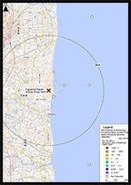
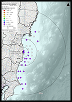
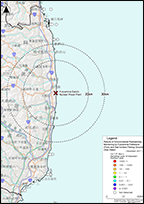
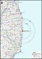
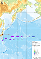
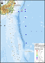
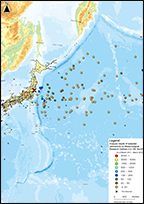
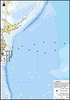
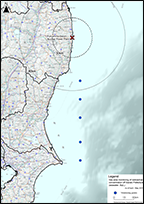
GPS MAP GRAPH I-131 Cs-134 Cs-137 Te-129m Sr-89 Sr-90 H-3 Other Nuclides

Organization
Tokyo Electric Power
Period
From March 2011 to September 2017
Summary
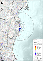
TEPCO is conducting seawater monitoring around TEPCO Fukushima Dai-ichi NPP since March 2011. At present, based on "General Monitoring Plan", the following two actions are taking place; (1) Frequen...
Current status of data collection
1 2 3 4 5 6 7 8 9 10 11 12
2011
2012
2013
2014
2015
2016
2017

GPS MAP GRAPH Cs-134 Cs-137 Sr-90 Pu-238 Pu-239+Pu-240 H-3 Other Nuclides

Organization
Fukushima Prefecture
Period
From June 2013 to April 2018
Summary
This data was created based on the monitoring results of seawater in the "Reinforcement of Monitoring in Fukushima Daiichi Nuclear Power Station Peripheral Sea Area" released to the public in t...
Current status of data collection
1 2 3 4 5 6 7 8 9 10 11 12
2013
2014
2015
2016
2017
2018
Readings of Sea Area Monitoring (Seawater) by NRA From May 2013 to Fabruary 2018

GPS MAP GRAPH I-131 Cs-134 Cs-137 Sr-89 Sr-90 H-3 Other Nuclides

Organization
Secretariat of the Nuclear Regulation Authority
Period
From May 2013 to Fabruary 2018
Summary
Based on "General Monitoring Plan", the Secretariat of the Nuclear Regulation Authority conducts sea area monitoring to figure out dispersion, deposition and migration of radioactive substances rel...
Current status of data collection
1 2 3 4 5 6 7 8 9 10 11 12
2013
2014
2015
2016
2017
2018

GPS MAP GRAPH I-131 Cs-134 Cs-137

Organization
Fukushima Prefecture
Period
From May 2011 to March 2017
Summary
This data was created based on the monitoring results of seawater in the "Results of Environmental Radioactivity Monitoring by Fukushima Prefecture (Ports and Sea Surface Fishing Ground)" relea...
Current status of data collection
1 2 3 4 5 6 7 8 9 10 11 12
2011
2012
2013
2014
2015
2016
2017

GPS MAP GRAPH Cs-134 Cs-137 H-3 Other Nuclides

Organization
Fukushima Prefecture
Period
From August 2013 to Jury 2015
Summary
This data was created based on the results of "Reinforcement of Environmental Radiation Monitoring in Examination Operation Sea Area" released to the public in the Fukushima Prefecture Governme...
Current status of data collection
1 2 3 4 5 6 7 8 9 10 11 12
2013
2014
2015

GPS MAP GRAPH Cs-134 Cs-137

Organization
Secretariat of the Nuclear Regulation Authority
Period
From December 2013 to January 2014
Summary
This data was created based on the results of "Survey of North Pacific Environmental Radioactivity Levels (2013)" by The General Environmental Technos Co., LTD. that were released to the public...
Current status of data collection
1 2 3 4 5 6 7 8 9 10 11 12
2013
2014
Results of Monitoring (Seawater) by MOE From June 2011 to November 2016

GPS MAP GRAPH Cs-134 Cs-137

Organization
The Ministry of the Environment
Period
From June 2011 to November 2016
Summary
The Ministry of Environment conducted emergency monitoring of devastated areas to comprehend if there was a leakage of radioactive substances released by the Fukushima Dai-ichi NPP accident followi...
Current status of data collection
1 2 3 4 5 6 7 8 9 10 11 12
2011
2012
2013
2014
2015
2016
Readings of Sea Area Monitoring (Seawater) by MEXT From March 2011 to January 2013

GPS MAP GRAPH I-131 Cs-134 Cs-137 Sr-90 Other Nuclides

Organization
The Ministry of Education, Culture, Sports, Science and Technology
Period
From March 2011 to January 2013
Summary
MEXT conducted emergency sea area monitoring around Fukushima Dai-ichi NPP from March 23, 2011 to investigate the distribution of radioactive substances released by the Fukushima Dai-ichi NPP accid...
Current status of data collection
1 2 3 4 5 6 7 8 9 10 11 12
2011
2012
2013
Monitoring Results of Aquatic Organisms (Seawater) From January 2012 to December 2016

GPS MAP GRAPH Cs-134 Cs-137 Sr-90

Organization
Ministry of the Environment
Period
From January 2012 to December 2016
Summary
This data was created based on the survey results at the shore from the "Monitoring Results of Aquatic Organisms" released to the public in the Ministry of the Environment website. In this...
Current status of data collection
1 2 3 4 5 6 7 8 9 10 11 12
2012
2013
2014
2015
2016
Results of Monitoring (Seawater) by JCG From August 2011 to August 2012

GPS MAP GRAPH Cs-134 Cs-137 Sr-90

Organization
Japan Coast Guard
Period
From August 2011 to August 2012
Summary
Based on "Comprehensive Radiation Monitoring Plan", Japan Coast Guard has long been conducting radiation monitoring in sea areas. Samples of sea water and marine soil in Tokyo bay and sea water off...
Current status of data collection
1 2 3 4 5 6 7 8 9 10 11 12
2011
2012

GPS MAP GRAPH Cs-134 Cs-137

Organization
Meteorological Research Institute
Period
From March 2011 to March 2012
Summary
Meteorological Research Institute of Japan Meteorological Agency (Tsukuba, Japan ) conducted sea water sampling in the wide area of pacific ocean after TEPCO Fukushima Dai-ichi NPP accident as a pa...
Current status of data collection
1 2 3 4 5 6 7 8 9 10 11 12
2011
2012

GPS MAP Cs-134 Cs-137

Organization
The Ministry of Education, Culture, Sports, Science and Technology
Period
From May 2011 to June 2011
Summary
Under contract by the MEXT, a charted ship of the Fisheries Research Agency collected sea water samples during their resource assessment survey (sampling period: May 16 - June 18, 2011). The sea w...
Current status of data collection
1 2 3 4 5 6 7 8 9 10 11 12
2011

GPS MAP GRAPH I-131 Cs-134 Cs-137

Organization
The Ministry of Education, Culture, Sports, Science and Technology
Period
From April 2011 to May 2011
Summary
TEPCO conducted sea water sampling by Japan Coast Guard's surveying vessel from April 25, 2011 to May 5, 2011. Sea water samples were collected from three layers (outer layer, middle layer and low...
Current status of data collection
1 2 3 4 5 6 7 8 9 10 11 12
2011