


No images are available for a selected survey
No images are available for a selected survey
No images are available for a selected survey
No images are available for a selected survey
No images are available for a selected survey
No images are available for a selected survey
No images are available for a selected survey
No images are available for a selected survey
No images are available for a selected survey
No images are available for a selected survey
No images are available for a selected survey
No images are available for a selected survey
No images are available for a selected survey
No images are available for a selected survey
No images are available for a selected survey
No images are available for a selected survey
No images are available for a selected survey
No images are available for a selected survey
No images are available for a selected survey
No images are available for a selected survey
No images are available for a selected survey
No images are available for a selected survey
No images are available for a selected survey
 ( Cs-137 )")
No images are available for a selected survey
No images are available for a selected survey
 ( Cs-134 )")
No images are available for a selected survey
 ( Cs-134+Cs-137 )")
No images are available for a selected survey
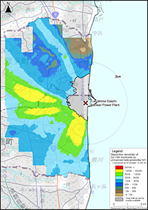
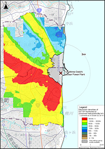
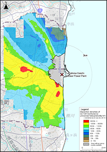
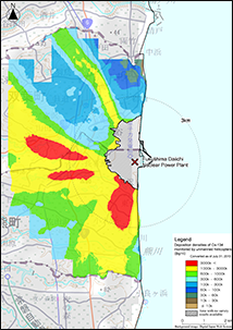
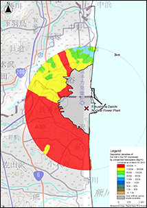
Results of Radioactive Cesium Deposition of the Unmanned Helicopter Monitoring within the 5 km Radius from the Fukushima Dai-ichi NPP ( From September 2016 to October 2016 )
- This data was created based on results of air dose rates measured by an unmanned helicopter within the 5 km radius of the Fukushima Dai-ichi NPP from September 1, 2016 to October 13, 2016 in the FY2016 Distribution Survey by NRA.
- Their flight altitude was 80 m above ground. The air dose rate at the ground surface is the averaged value of gamma dose in an 80 m diameter circle (varies by flight altitude) below the aircraft.
- The width of the track of the unmanned helicopter was 80 m.
- The flight velocity was approximately 8 m/s (28.8 km/h).
- Using a LaBr3(Ce) (lanthanum bromide) scintillation detector (ø 1.5" × 1.5" × 3 pcs), gamma ray from the ground and the direct and scattered gamma ray radiation from the NPP (counting rate), as well as energy spectra were measured every one second.
- The air dose rates of radioactive cesium (cesium-134, 137) were obtained by subtracting the average air dose rate (43±20 nSv/h, error = standard deviation σ) due to natural radionuclides (potassium 40, uranium series, and thallium series), from the measured values of the in-situ measurement using germanium semiconductor detector in the restricted area. Subsequently, using the conversion factor between the air dose rate at a height of 1 m above the ground and the deposition density of radioactive cesium at relaxation mass β = 1.0 g/cm2 (Refer to "Method of the in-situ measurement using germanium semiconductor detectors" of MEXT's Radiation Measurement Method Series No.33), deposition densities of cesium 134 and cesium 137 were derived.
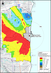
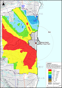
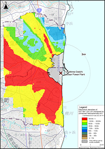
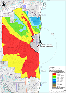
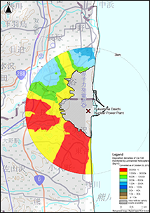
Results of Radioactive Cesium Deposition of the Unmanned Helicopter Monitoring within the 5 km Radius from the Fukushima Dai-ichi NPP ( From September 2015 to October 2015 )
- This data was created based on results of air dose rates measured by an unmanned helicopter within the 5 km radius of the Fukushima Dai-ichi NPP from September 2, 2015 to October 22, 2015 in the FY2015 Distribution Survey by NRA.
- Their flight altitude was 80 m above ground. The air dose rate at the ground surface is the averaged value of gamma dose in an 80 m diameter circle (varies by flight altitude) below the aircraft.
- The width of the track of the unmanned helicopter was 80 m.
- The flight velocity was approximately 8 m/s (28.8 km/h).
- Using a LaBr3(Ce) (lanthanum bromide) scintillation detector (ø 1.5" × 1.5" × 3 pcs), gamma ray from the ground and the direct and scattered gamma ray radiation from the NPP (counting rate), as well as energy spectra were measured every one second.
- The air dose rates of radioactive cesium (cesium-134, 137) were obtained by subtracting the average air dose rate (43±20 nSv/h, error = standard deviation σ) due to natural radionuclides (potassium 40, uranium series, and thallium series), from the measured values of the in-situ measurement using germanium semiconductor detector in the restricted area. Subsequently, using the conversion factor between the air dose rate at a height of 1 m above the ground and the deposition density of radioactive cesium at relaxation mass β = 1.0 g/cm2 (Refer to "Method of the in-situ measurement using germanium semiconductor detectors" of MEXT's Radiation Measurement Method Series No.33), deposition densities of cesium 134 and cesium 137 were derived.
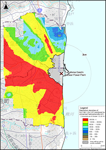
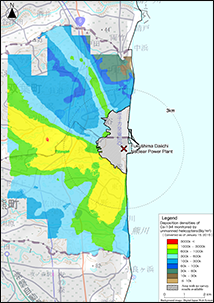
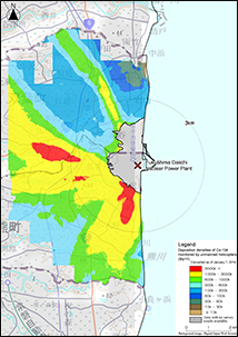
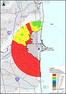
Results of Radioactive Cesium Deposition of the Unmanned Helicopter Monitoring within the 5 km Radius from the Fukushima Dai-ichi NPP ( From November 2014 to January 2015 )
- This data was created based on results of air dose rates measured by an unmanned helicopter within the 5 km radius of the Fukushima Dai-ichi NPP from November 13, 2014 to January 15, 2015 in the FY2014 Distribution Survey by NRA.
- Their flight altitude was 80 m above ground. The air dose rate at the ground surface is the averaged value of gamma dose in an 80 m diameter circle (varies by flight altitude) below the aircraft.
- The width of the track of the unmanned helicopter was 80 m.
- The flight velocity was approximately 8 m/s (28.8 km/h).
- Using a LaBr3(Ce) (lanthanum bromide) scintillation detector (ø 1.5" × 1.5" × 3 pcs), gamma ray from the ground and the direct and scattered gamma ray radiation from the NPP (counting rate), as well as energy spectra were measured every one second.
- The air dose rates of radioactive cesium (cesium-134, 137) were obtained by subtracting the average air dose rate (43±20 nSv/h, error = standard deviation σ) due to natural radionuclides (potassium 40, uranium series, and thallium series), from the measured values of the in-situ measurement using germanium semiconductor detector in the restricted area. Subsequently, using the conversion factor between the air dose rate at a height of 1 m above the ground and the deposition density of radioactive cesium at relaxation mass β = 1.0 g/cm2 (Refer to "Method of the in-situ measurement using germanium semiconductor detectors" of MEXT's Radiation Measurement Method Series No.33), deposition densities of cesium 134 and cesium 137 were derived.
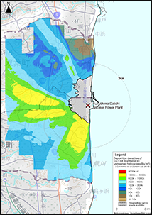
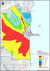
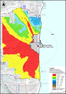
Results of Radioactive Cesium Deposition of the Unmanned Helicopter Monitoring within the 5 km Radius from the Fukushima Dai-ichi NPP ( From June 2014 to July 2014 )
- This data was created based on results of air dose rates measured by an unmanned helicopter within the 5 km radius of the Fukushima Dai-ichi NPP from June 23, 2014 to July 22, 2014 in the FY2014 Distribution Survey by NRA.
- Their flight altitude was 80 m above ground. The air dose rate at the ground surface is the averaged value of gamma dose in an 80 m diameter circle (varies by flight altitude) below the aircraft.
- The width of the track of the unmanned helicopter was 80 m.
- The flight velocity was approximately 8 m/s (28.8 km/h).
- Using a LaBr3(Ce) (lanthanum bromide) scintillation detector (ø 1.5" × 1.5" × 3 pcs), gamma ray from the ground and the direct and scattered gamma ray radiation from the NPP (counting rate), as well as energy spectra were measured every one second.
- The air dose rates of radioactive cesium (cesium-134, 137) were obtained by subtracting the average air dose rate (43±20 nSv/h, error = standard deviation σ) due to natural radionuclides (potassium 40, uranium series, and thallium series), from the measured values of the in-situ measurement using germanium semiconductor detector in the restricted area. Subsequently, using the conversion factor between the air dose rate at a height of 1 m above the ground and the deposition density of radioactive cesium at relaxation mass β = 1.0 g/cm2 (Refer to "Method of the in-situ measurement using germanium semiconductor detectors" of MEXT's Radiation Measurement Method Series No.33), deposition densities of cesium 134 and cesium 137 were derived.
Results of Radioactive Cesium Deposition of the Unmanned Helicopter Monitoring within the 5 km Radius from the Fukushima Dai-ichi NPP ( From November 2013 to January 2014 )
- This data was created based on results of air dose rates measured by an unmanned helicopter within the 5 km radius of the Fukushima Dai-ichi NPP from November 19, 2013 to January 7, 2014 in the FY2013 Distribution Survey by NRA.
- Their flight altitude was 80 m above ground. The air dose rate at the ground surface is the averaged value of gamma dose in an 80 m diameter circle (varies by flight altitude) below the aircraft.
- The width of the track of the unmanned helicopter was 80 m.
- The flight velocity was approximately 8 m/s (28.8 km/h).
- Using a LaBr3(Ce) (lanthanum bromide) scintillation detector (ø 1.5" × 1.5" × 3 pcs), gamma ray from the ground and the direct and scattered gamma ray radiation from the NPP (counting rate), as well as energy spectra were measured every one second.
- The air dose rates of radioactive cesium (cesium-134, 137) were obtained by subtracting the average air dose rate (43±20 nSv/h, error = standard deviation σ) due to natural radionuclides (potassium 40, uranium series, and thallium series), from the measured values of the in-situ measurement using germanium semiconductor detector in the restricted area. Subsequently, using the conversion factor between the air dose rate at a height of 1 m above the ground and the deposition density of radioactive cesium at relaxation mass β = 1.0 g/cm2 (Refer to "Method of the in-situ measurement using germanium semiconductor detectors" of MEXT's Radiation Measurement Method Series No.33), deposition densities of cesium 134 and cesium 137 were derived.
- Regarding air dose rates, dead time was corrected because 1.8 - 2.0μs dead time had been found in the radiation measurement system of the unmanned helicopter when evaluated by irradiation equipment.
Results of Radioactive Cesium Deposition of the Unmanned Helicopter Monitoring within the 5 km Radius from the Fukushima Dai-ichi NPP ( From June 2013 to July 2013 )
- This data was created based on results of air dose rates measured by an unmanned helicopter within the 5 km radius of the Fukushima Dai-ichi NPP from June 6, 2013 to July 31, 2013 in the FY2013 Distribution Survey by NRA.
- Their flight altitude was 80 m above ground. The air dose rate at the ground surface is the averaged value of gamma dose in an 80 m diameter circle (varies by flight altitude) below the aircraft.
- The width of the track of the unmanned helicopter was 80 m.
- The flight velocity was approximately 8 m/s (28.8 km/h).
- Using a LaBr3(Ce) (lanthanum bromide) scintillation detector (ø 1.5" × 1.5" × 3 pcs), gamma ray from the ground and the direct and scattered gamma ray radiation from the NPP (counting rate), as well as energy spectra were measured every one second.
- The air dose rates of radioactive cesium (cesium-134, 137) were obtained by subtracting the average air dose rate (43±20 nSv/h, error = standard deviation σ) due to natural radionuclides (potassium 40, uranium series, and thallium series), from the measured values of the in-situ measurement using germanium semiconductor detector in the restricted area. Subsequently, using the conversion factor between the air dose rate at a height of 1 m above the ground and the deposition density of radioactive cesium at relaxation mass β = 1.0 g/cm2 (Refer to "Method of the in-situ measurement using germanium semiconductor detectors" of MEXT's Radiation Measurement Method Series No.33), deposition densities of cesium 134 and cesium 137 were derived.
- Regarding air dose rates, dead time was corrected because 1.8 - 2.0μs dead time had been found in the radiation measurement system of the unmanned helicopter when evaluated by irradiation equipment.
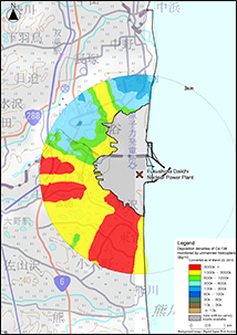
Results of Radioactive Cesium Deposition of the Second Unmanned Helicopter Monitoring within the 3 km Radius from the Fukushima Dai-ichi NPP ( Decay correction: March 20, 2013 )
- This data was created based on the results of air dose rates measured from January 27, 2013 to March 7, 2013 in the Third Distribution Survey by MEXT.
- Their flight altitudes were from 50 to 80 m above ground. The air dose rate at the ground surface is the averaged value of gamma dose in a roughly 50 m to 80 m diameter circle (varies by flight altitude) below the aircraft.
- The widths of the track of the unmanned helicopter were 50 m or 80 m.
- The flight velocity was approximately 8 m/s (28.8 km/h).
- Using a LaBr3(Ce) (lanthanum bromide) scintillation detector (ø1.5" × 1.5" × 3 pcs), gamma ray from the ground and the direct and scattered gamma ray radiation from the NPP (counting rate), as well as energy spectra were measured every one second.
- The air dose rates of radioactive cesium were obtained by subtracting 43 nSv/h, the average air dose rate due to natural radionuclides (derived by the in-situ measurement using germanium semiconductor detector in the restricted area), from the measured values. Subsequently, using the conversion factor between the air dose rate at a height of 1 m above the ground and the deposition density of radioactive cesium at relaxation mass β = 1.0 g/cm2 (Refer to "Method of the in-situ measurement using germanium semiconductor detectors" of MEXT's Radiation Measurement Method Series No.33), deposition densities of cesium 134 and cesium 137 were derived.
Results of Radioactive Cesium Deposition Measurement in Riverbank by Unmanned Helicopter ( Decay correction: January 31, 2013 )
- This data was created based on the results of air dose rates measured from January 8, 2013 to January 31, 2013 for Abukumagawa river basin (Miyagi Prefecture) and from October 31, 2012 to November 7, 2012 for Udagawa river basin (Soma City, Fukushima Prefecture) in the Third Distribution Survey by MEXT.
- Their flight altitudes were from 50 to 80 m above ground. The air dose rate at the ground surface is the averaged value of gamma dose in a roughly 50 m to 80 m diameter circle (varies by flight altitude) below the unmanned helicopter.
- The widths of the track of the unmanned helicopter were 50 m or 80 m.
- The flight velocity was approximately 8 m/s (28.8 km/h).
- Using a LaBr3(Ce) (lanthanum bromide) scintillation detector (ø1.5" × 1.5" × 3 pcs), gamma ray from the ground and the direct and scattered gamma ray radiation from the NPP (counting rate), as well as energy spectra were measured every one second.
- The air dose rates of radioactive cesium were obtained by subtracting 43 nSv/h, the average air dose rate due to natural radionuclides (derived by the in-situ measurement using germanium semiconductor detector in the restricted area), from the measured values. Subsequently, using the conversion factor between the air dose rate at a height of 1 m above the ground and the deposition density of radioactive cesium at relaxation mass β = 1.0 g/cm2 (Refer to "Method of the in-situ measurement using germanium semiconductor detectors" of MEXT's Radiation Measurement Method Series No.33), deposition densities of cesium 134 and cesium 137 were derived.
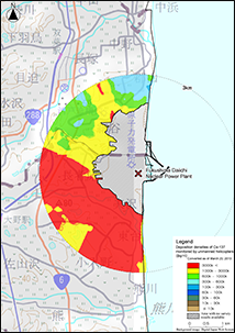
Results of Radioactive Cesium Deposition of the First Unmanned Helicopter Monitoring within the 3 km Radius from the Fukushima Dai-ichi NPP ( Decay correction: October 20, 2012 )
- This data was created based on results of air dose rates measured from October 2, 2012 to October 20, 2012 in the Third Distribution Survey by MEXT.
- Their flight altitudes were from 50 to 80 m above ground. The air dose rate at the ground surface is the averaged value of gamma dose in a roughly 50 m to 80 m diameter circle (varies by flight altitude) below the aircraft.
- The widths of the track of the unmanned helicopter were 50 m or 80 m.
- The flight velocity was approximately 8 m/s (28.8 km/h)
- Using a LaBr3(Ce) (lanthanum bromide) scintillation detector (ø1.5" × 1.5" × 3 pcs), gamma ray from the ground and the direct and scattered gamma ray radiation from the NPP (counting rate), as well as energy spectra were measured every one second.
- The air dose rates of radioactive cesium were obtained by subtracting 43 nSv/h, the average air dose rate due to natural radionuclides (derived by the in-situ measurement using germanium semiconductor detector in the restricted area), from the measured values. Subsequently, using the conversion factor between the air dose rate at a height of 1 m above the ground and the deposition density of radioactive cesium at relaxation mass β = 1.0 g/cm2 (Refer to "Method of the in-situ measurement using germanium semiconductor detectors" of MEXT's Radiation Measurement Method Series No.33), deposition densities of cesium 134 and cesium 137 were derived.
Results of Radioactive Cesium Deposition of the Unmanned Helicopter Monitoring within the 5 km Radius from the Fukushima Dai-ichi NPP ( From September 2016 to October 2016 )
Results of Radioactive Cesium Deposition of the Unmanned Helicopter Monitoring within the 5 km Radius from the Fukushima Dai-ichi NPP ( From September 2015 to October 2015 )
Results of Radioactive Cesium Deposition of the Unmanned Helicopter Monitoring within the 5 km Radius from the Fukushima Dai-ichi NPP ( From November 2014 to January 2015 )
Results of Radioactive Cesium Deposition of the Unmanned Helicopter Monitoring within the 5 km Radius from the Fukushima Dai-ichi NPP ( From June 2014 to July 2014 )
Results of Radioactive Cesium Deposition of the Unmanned Helicopter Monitoring within the 5 km Radius from the Fukushima Dai-ichi NPP ( From November 2013 to January 2014 )
Results of Radioactive Cesium Deposition of the Unmanned Helicopter Monitoring within the 5 km Radius from the Fukushima Dai-ichi NPP ( From June 2013 to July 2013 )
Results of Radioactive Cesium Deposition of the Second Unmanned Helicopter Monitoring within the 3 km Radius from the Fukushima Dai-ichi NPP ( Decay correction: March 20, 2013 )
Results of Radioactive Cesium Deposition Measurement in Riverbank by Unmanned Helicopter ( Decay correction: January 31, 2013 )
Results of Radioactive Cesium Deposition of the First Unmanned Helicopter Monitoring within the 3 km Radius from the Fukushima Dai-ichi NPP ( Decay correction: October 20, 2012 )
There is no content for 'Download File'
Results of Radioactive Cesium Deposition of the Unmanned Helicopter Monitoring within the 5 km Radius from the Fukushima Dai-ichi NPP ( From September 2016 to October 2016 )
CSV(Unified format)
Results of Radioactive Cesium Deposition of the Unmanned Helicopter Monitoring within the 5 km Radius from the Fukushima Dai-ichi NPP ( From September 2015 to October 2015 )
CSV(Unified format)
Results of Radioactive Cesium Deposition of the Unmanned Helicopter Monitoring within the 5 km Radius from the Fukushima Dai-ichi NPP ( From November 2014 to January 2015 )
CSV(Unified format)
Results of Radioactive Cesium Deposition of the Unmanned Helicopter Monitoring within the 5 km Radius from the Fukushima Dai-ichi NPP ( From June 2014 to July 2014 )
CSV(Unified format)
- FY2016 Nuclear Regulation Authority Commissioned Project Report "Summary of Distribution Data of Radioactive Substances Stemming from the Fukushima Daiichi Nuclear Power Plant Accident"
- FY2015 Nuclear Regulation Authority Commissioned Project Report "Summary of Distribution Data of Radioactive Substances Stemming from the Fukushima Daiichi Nuclear Power Plant Accident"
- The Report of the Nuclear Regulation Authority Commissioned Project in FY 2014 - The Collection of the Radioactive Substances Distribution Data, and the Development of a Migration Model Associated with Fukushima Daiichi Nuclear Power Plant Accident -
- FY 2013 Nuclear Regulation Authority Commissioned Project Report "Establishment of A Comprehensive Approach of Long Term Effects by Radioactive Substances Due to Fukushima Daiichi Nuclear Power Plant Accident"
- FY 2012 Commissioned Project - Radioactivity Measurement and Investigation "Establishment of A Comprehension Approach of Long Term Effects by Radioactive Substances Due to Fukushima Daiichi Nuclear Power Plant Accident" Report